share for indonesian

Senin, 30 Agustus 2010

Beautiful Parahyangan "Place decrease Gods"

Parahyangan or Priangan is the Sunda area in West Java with an area covering an area of Ciamis, Tasikmalaya, Garut, Sumedang, Cimahi, Bandung and Cianjur.


Priangan or Parahyangan often interpreted as the place where the rahyang or hyang. The place is very beautiful for lovers of nature tourism.


Priangan currently is one area of West Java Province, which includes the District Cianjur, Bandung, Sumedang, Garut, Tasikmalaya and Ciamis, which covers approximately one sixth of the island of Java (approximately 21 524 square km). Priangan bordering the northern part of Karawang, Purwakarta, Subang and Indramayu; the south with Majalengka, Kuningan, with Central Java in the east bounded by the river Citanduy; in the western borders of Bogor and Sukabumi, whereas in the south faced by the Indonesian Ocean.

Nature Tourism
Relief Priangan land area is formed by low plains, hills and mountains create a series of Priangan become a paradise for lovers of nature tourism. Mount series from Mount Gede, Mount Ciremai, Mount Mounts, Mount Masigit, Mount Salak, Mount Tangkuban Perahu, Mt Burangrang, Mount Malabar, Mount Hill stumps, Mount Tampomas, Mount Calancang, Cakra Buana Mountain, Thunder Mountain, Mount Haruman, Mount Talagabodas, Mount Karacak, Galunggung, Mount cupu, Mount rhino horns, Hunchback Mountain, Mount Syawal.

The mountains that surround this Priangan equipped many rivers that make it a very fertile area Priangan.


Culinary

Enjoy the trip without food will taste bland. In Priangan many typical foods that have spread in various areas, such as Tofu Sumedang, Dodo Garut, TO (tutug Oncom) at Tasik, Ciamis has galendo, and many more. This cuisine is guaranteed to make the tourists happy with the taste and a very diverse species.

Raja Ampat "Coral Triangle Center, World paradise"

Raja Ampat is one of regencies in the province of West Papua, Indonesia. This district capital is located in Waisai. Raja Ampat Islands located in the northwest part of Papua Province has a total area of land and sea around 9.8 million acres. Looking at his position in the triangle area of coral reef, right in the center of diversity of coral reefs worldwide, the Raja Ampat Islands sea area is indicated as the richest biodiversity in the world.


An extensive collection of coral reefs and prove that this rich coral reefs in these islands to survive against threats like coral bleaching and disease, two types of threats that are now seriously endanger the survival of coral reefs worldwide. Strong ocean currents in Raja Ampat plays an important role in the spread of coral larvae across the Indian and Pacific oceans to the other reef ecosystems. Capability is supported by the diversity and resilience make this region a top priority for protection.In 2002, The Nature Conservancy (TNC) and its partners conducted a scientific survey to obtain data and information about marine ecosystems, mangroves, and forests of the Raja Ampat Islands. This survey shows that there are some 537 species of coral, which is really exciting because it represents about 75% of reefs in the world. In addition, 828 species of fish and estimated the total number of fish species in this region 1074. On land, the survey found lush forests, endemic and rare plants, plants in the limestone as well as thousands of sea turtle nesting beaches.

Human activities on these islands have yet to demonstrate a significant negative impact compared with coral reef areas elsewhere in Indonesia, but the threats because the practices are not environmentally friendly such as the use of bombs, poison (cyanide), turtle egg collection and logging do not pay attention to the aspects of sustainability is expected to disrupt the integrity of existing ecosystems. The Indonesian government has just set the Raja Ampat region as a new independent district, which is a great opportunity for local communities to manage natural resources for the future of the Raja Ampat their lives. The new government is also considering offering the opportunity to participate in the conservation aspects in spatial planning for the new district.


Raja Ampat consists of four major islands, namely smalldam, Batanta, Salawati and Misool and hundreds of smaller islands. The islands are part of the expanse of ocean areas that include the Bird's Head area of Paradise Bay, the largest marine national park in Indonesia.

Drying Island "Truely Indonesia"

Drying Island (area 250 ha) is owned by an Indonesian island located in the Strait of Malacca, near the border with Malaysia. The island is included in Rokan Hilir regency, Riau province. It is located approximately 72.4 kilometers from Bagansiapiapi and 64.3 km from Port Klang in Malaysia. This island is the largest island of the archipelago of Spirits, the group of nine islands, including Pulau Drying, Tokong Gold, Tokong Simbang and Labuhan booth.

Drying island famous for its scenery and white sandy beaches such as habitat for green turtles. Waters surrounding the island is famous as a fish-producing areas.
Drying island in the Malacca Straits region, have the potential to beautiful beaches. Unfortunately, local governments have not maximally manage the island without inhabitants. After Kepulauan Riau (Riau Islands) stand on their own into the province, the Riau has lost its beach a tourist attraction. Now one area that has a beautiful beach area, exist only in Rokan Hilir (rohil) ie Drying Island in the Strait of Malacca.


Drying Island, located approximately 45 miles from the capital rohil, Bagansiapiapi and 45 miles from mainland Malaysia. This uninhabited island is geographically closer to North Sumatra. Hardly, the island had become sengkata between Riau and North Sumatra Province. Understandably, around the island, a fish-producing areas. In fact, in the 1960s, the sea around the island Drying never holds the world's largest fish producer, after Norway.
Drying of this island, is actually a cluster of islands consisting of, Pulau Tekong Mas, Simbang Tekong, Pulau Labuhan pualu booth as well as other small islands. Pualu islands that surround the island Drying it in a circle so that its center is a calm sea. Some islands are called Spirits of the island region. Every day, the Spirits of the island region is, of Rokan Hilir, more than 3000 fishermen fishing in the area. This is not to mention the other fishermen from the North. And the fishing activities in the region, estimated at more than 5000 fishermen.


Dry Island has panoramic views and beautiful nature. Besides the island with an area of only three hectares is also very rich with the marine and coral reefs. There is also terapat green turtle species was supposedly the only one in Indonesia. In certain seasons, sea turtles, green turtles climbed ashore and lay eggs. At least, once a turtle laying its eggs under the soil layer deviates between 100 to 150 eggs each turtle. Also in this Jemur Island, there are also several potential tourist attractions in Goa include Jepng, flare tower, the remaining Japanese pertahana, stone screen commander, and Marine Park and the sandy beaches of yellow gold.

Tourism objects Bledug Kuwu

Indonesian nature we are very rich in natural and cultural diversity, a lot of tourist attractions that exist in Indonesia is that not many people know, one of whom is a Tourist Attraction Bledug Kuwu existing Java Purwodadi Tengah.Tempat tourist area this one is unique, very different from the places other tours, these resorts named Bledug Kuwu. If the United States we can find the Salt Lake (plain salt) derived from the shallow sea and then turned into a vast land, and at this time the mainland is often used as a testing ground in the world's fastest cars. As with the shallow sea located in Indonesia, as well as a miracle of nature that are not owned by other countries, his name bledug kuwu, situated beside kluwu village, subdistrict, district kradenan Grobogan, also because suaranay that periodically blow bledug sound (like the cannon heard in the distance) from the mud along with the release of bubbles of smoke, salt.


Through this process makes the land that used to be based bledug sea, is now the mainland that have a height of approximately 53m from the sea surface. 45Ha Area of their area with a minimum temperature 31derajat celcius.

Rabu, 25 Agustus 2010

Enjoying Eksotisitas Mount Talamau

KabarIndonesia - West Pasaman (Pasbar) may be regarded as still relatively new district, compared to other districts who first developed, yet so Pasbar also has a variety of natural potential is no less beautiful with another district in West Sumatra (Sumatra).

With the potential of natural attractions and Mount Mount Talamau Pasaman make West Pasaman become more powerful and seems like a giant wake up from sleep with the hope of mensejajar themselves with other districts in West Sumatra.
Talamau indeed majestic mountain, located in the Nagari Pinagar Aur Kuning Pasaman District, West Pasaman (Pasbar), indicating a high wooden manjulang Mount Talamau was still beautiful, has an altitude of about 2900 km above sea level, accompanied Talamau Dozens of waterfalls, and the top decorated lake and surrounded by dozens of colorful carpet of flowers to make the beauty of Mount Talamau increasingly attractive.

From my search, along with the Nature Lovers Group (KPA) Gabher Pasaman West Pasaman (Pasbar) for one Sunday at Mount Talamau, early stage to make a trip to the summit of Mount Talamau can be started from the center of the Roundabout Intersection Pasbar District Four District Pasaman, with using two-or four-wheel vehicle to the exact intersection of irrigation water gate at the foot of the Mount and then continued on foot with a fairly challenging climbing route takes approximately one hour to reach, only then will reach the first shelter that is Tiger Hill Campo.

On This Campo Tiger hill climbers can spend the night by setting up a tent or just tired melapas can also enjoy the beauty of the moment as he looked out how the arrangement of the Four Paths in the City, and Beautiful afternoon sun sank in the Beach District Sasak Sasak Pasisia domains. In addition to rest while enjoying the beautiful view from Tiger Hill Campo.

approximately 100 meters climbers can also enjoy the beautiful waterfalls lenggogeni, reportedly has a legend of the waterfall is interesting to note, allegedly lenggogeni story waterfall is a bathing place of the princess in ancient days. After resting Mount tiger Campo, travel and then forwarded to the next shelter or the shelter II used to say the climbers ie Rindu Alam, with approximately four-hour journey, the climbers had to be extra careful because in order to Rindu Alam had to go through a few creeks with rocks the slick, challenging path and added the blood-sucking beast that is Pacet (kind Leeches) ready to attach to and suck the blood of the climbers. In addition to rest and fill the water for drinking supplies to the shelter the next area of natural longing Pacet climbers can also check at the feet or hands attached.

While the natural desire to shelter Sarasah Earth III or climbing trip will take about six hours. After reaching the Earth Sarasah then the climbers will explore the most challenging climbing routes to the shelter paninjauan or IV with a steep rocky road here will be increasingly tested climbers if not careful will slip because of the steep and slippery rocks from the Earth's journey toward paninjauan consuming Sarasah take about four hours.

After making a gradual ascent from the shelter I, II, III and IV, finally arriving in Padang siranjano, do not forget we say "Assalamu'alaikum" when entering the area of Padang Siranjano because here where dozens of lakes, such as talago Biru.Talago Bagindo Rajo, Talago Puti, Talago Lumuik and other talago.

After one day of walking finally achieved the ideals that is, until the highest peak or TOP Talamau Eagle Peak, elevation about 2900 meters above sea level, at the top talamau tired, tired, no longer feels the beauty of nature into a cure for us, the beauty of God's creation did not both as far as the eye could see, "Talamau I Love You" after being satisfied the wild look of the Top G. Talamau, we took pictures, we returned to take about six hours to the city four intersections. (*)

Geopark, Pacitan Karst Regions Tourism


KabarIndonesia - Tourists, especially from foreign countries, want a treat unique and original. To that end, the necessary human resources (HR) who qualified in the field of tourism. Thus, the level of tourist visit to Indonesia each year has increased. "Human Resource Development of tourism industry players important enough to boost the level of tourist visits to Indonesia," said Winarno Sudjar, Secretary of the Directorate General of Tourism Destination Development, Ministry of Culture and Tourism, met sidelines of Tourism Workshop Facilitation of Business Development, Pacitan Hall, Wednesday ( 15 / 7).

Data from Disbudpar shows, the level of tourist visit to Indonesia during the period January-April 2009 reached 1.8 million tourists. This amount increased by 1.5 percent compared to same period last year. In the year 2008 the total tourist traffic to reach 6 million people. However this figure is still below the level of tourist visits to other countries such as Malaysia, Singapore and China. "The potential of tourism we can not lose. It's just that our service problem left behind, "said Winarno.

Increased HR actors tourism industry, go Winarno is very important. The reason is, travelers who want more services from their destination. Not only comfort, safety is also required for travelers to visit. In fact, other factors such as food and fruit hand should also be considered.

Meanwhile, Vice Regent Pacitan, HG Sudibyo admitted that so far the role of human resources in the world of tourism is not adequate. Therefore, Pemkab Pacitan the future will be every effort to improve human resources in tourism through the recruitment of civil servants. For investors who will invest in tourism will also be provided convenience. "We will provide convenience for investors in Pacitan."

Tourism Business Development Facilitation activities will be held over two days, 15 to 16 July. Agenda activities include debriefing of the introduction of tourism to the tourism potential of youth, tourism, business building workshops and technical guidance for tourism businesses. In the last days later, the activities will be filled with social work in the area of tourism in the district of Goa Gong Punung. (*)

Packaged in a package of East Flores Tour


KabarIndonesia - Packing East Flores (Flotim) in a package tour is not an impossible thing. The region has diverse tourism potential, both cultural and natural tourist attractions that captivate. Not only that, the topography of steep mountainous regions, such as mountains suddenly appear on the surface of the sea.

Towns and villages perched on the beach or on steep slopes nan. All this pampering eyes of anyone who visited the region. In this perdanannya edition "Vote Nucalele" offers a tour package for you to visit this land of a thousand islands.

East Flores Larantuka as the old town opposite the Adonara and make it elegant Solor as a port town on the shores of the lake. As the center of East Flores regency government, Larantuka continue efforts to organize themselves by not leaving Lamaholot cultural distinctiveness. The touch of Roman culture, Portuguese and Malays in conjunction with Christian religiosity, giving the impression and wonderful memories for everyone who visits.

City tour begins from Larantuka. In this city of Christian symbols like the Statue of Our Lady (Master Ma), the statue of the Lord Jesus (Master Ana), churches and chapels as well as the Palace of King Larantuka in Roman architecture and the Portuguese era had already confirmed the identity of this city as a religious city. In this region the population lives almost entirely dependent on dry land farming. Since it has only one growing season, the time between seasons filled with work as fishermen or craftsmen. Partly fill the time with a wander, characteristic of high mobility rate.

Man's life is supported entirely by women working in the garden and make the job a hereditary effeminacy as weaving and weaving. Keep in mind, many residents are also fishermen, especially those who live in the coastal areas.

In the town of Larantuka, you will be pampered with beautiful beaches such as the Coast Weri. The beauty of this beach is truly stunning scenery and sprinkled with white sand island diseberangnya Adonara. This beach is only 5 kilometers east direction Larantuka. Accessible by the public transportation terminal at any time on a route-Weri Larantuka. Approximately one kilometer west of the cave and there Weri Beach Statue Virgin Mary as a Catholic shrine.

Enjoy the beauty of the Coast Weri satisfied, you can move approximately five miles to the east toward the Village Mudakeputu. In this village you can see the various upaca customary, traditional dances such as the dance was Hedung, Soka Meraj etc. crossbar. Can also be witnessed the process of making woven products using natural dyes and the process of making corn which is a typical food titi East Flores. In the village of Young decree, you can also see the buildings and meeting places with architectural tradition that pamper the eye area.
There are also tours the Rock Umbrella. Umbrella is a natural stone formation of reefs with a height of approximately 6 meters and a giant umbrella-shaped 4.5-meter diameter. Located at the tip of the cape Watu Umbrella, District of Tanjung Bunga. Can be reached by motorboat from Waiklibang within 90 minutes.

Not far from the Rock Umbrella, precisely in the Village Waibao, there are inscribed stones found in 1985 Nopin Keep on Keep Nopin region. These sites have stone letters that read Java / Bali and is estimated as a relic of ancient Gajah Mada. This site is very interesting because Gajah Mada known to disappear into the eastern part of Indonesia. Could this region become a place where the Divine Patih buried?

In this place there is also the entrance from the beach Painghaka called the "Gate of the hymn". The beach area is reputedly Painghaka stopover port merchants long ago with the discovery peniggalan antiquities in the region. Can be reached by walking 12 km from the village of Waibao, across the gardens of maize the main attraction. Can also be reached by sea from Waiklibang motor for 60 minutes.

Waibao Village also presents natural freshwater lake called Lake Waibelen. Formed by an eruption of Mount Ile Sodoberawao Kobanara years 400-500 BC. Diameter of 500 meters and its depth reaches 20 meters. Lake Waibelen also known as Lake sepesang occurrence of Asmara to commemorate the daring youth suicide sink to the bottom of the lake because of the love they did not get parental consent. In this lake there are also animals that White Crocodile step by local people greeted him as "grandmother". This lake can only travel by foot ditempu 500 meters from the village of Waibao.

Not only to travel here. Along the northern coast of East Flores, you are presented with a panoramic Kawaliwu Coast. The beach is located in the Village Sinarhadinggala Lewolema District has its own peseona. Especially when the sunset. Panai around upaca can also be witnessed indigenous communities. Former raging waves of the tsunami in 1992 could still be seen. Only with travel time approximately 30 minutes from Larantuka, making this panati never be devoid of visitors.

Tired Kawaliwu Beach panorama, you will be refreshed with hot water to soak dipemandian Oka. This spa is very strategic location ie in streets of Maumere - Larantuka. Oka hot water bathing is always an option for the most recent visit to the manic nature tours before returning to Larantuka to end their tour trip.

Travel Tips
Larantuka easily be reached from all directions. If the former is only from the sea, can now also by plane from Kupang with 45-minute long journey landing on airfield Gewayan Land. Meanwhile, from Maumere, is accessible by road along 137 kilometers. There are many to choose from such as the inn Hotel Rulies, Tresna, Fortuna I and II, Hotekl Shalom and some other hotels. Everything is located in downtown Larantuka. (*)

Kamis, 12 Agustus 2010

Sanur Beach Bali

Sanur beach is a beach because the beach is the historic beach where the landing of the Dutch royal army when the Dutch attacked the territory during the colonial period Badung

Among tourism, Sanur beach was first introduced by the artist from Belgium named AJ Le Mayeur and his wife Ni Polok who settled in Sanur since 1937. In 1963 tourism impact on the state increasingly felt with the establishment of Sanur Bali Beach Hotel (now The Grand Bali Beach Inna which is the first hotel built in Bali. Until now this area is still one of the major tourist destinations in the city of Denpasar.
In an effort to increase the attractiveness of a tourism area of Sanur, since 2006, implemented the Sanur Village Festival. Sanur Village Festival is an annual event held in Sanur routine. The event was initiated by community of Sanur, the Sanur Development Foundation and dudukung by the Government of Denpasar.

Lake Maninjau

Maninjau lake located at an altitude of ± 500 m above sea level and surrounded by the Bukit Barisan and the towering steep, making the Lake Maninjau are like a giant crater. known also as having a lot of romantic places, so normal that many foreign tourists call it the lake with romantic scenes because of the side wherever you see it will look stunning scenery.

Maninjau lake formed by volcanic eruptions (Mountain View) in the past. This beautiful lake is situated ± 36 km from Bukittinggi towards the west which can be reached by public transportation purposes and Lubuk Maninjau cone with a unique 44 meanders through a breadth of about 99.5 km ² and a maximum depth of 495 meters.
The existence of Lake Maninjau created a legend "Bujang Nine", which is trusted by the public about its existence. Once there was a family consisting of 10 men, nine men (flunky) and a woman named Sani. Keelokkan appearance and behavior of Sani became a separate appeal for a young man named Sigiran. In short, they then establish romance. One day they were accused of immoral acts by the footman. To prove it, they jump into the crater of Review. They swear if they commit an act of immoral then the mountain will not erupt, and if they do not do this immoral then the mountain would erupt. Finally, the volcano erupted and the eruption of a large crater was formed which was then filled with water and become lakes like now.
First President Ir. Sukarno had visited the Lake Maninjau and was amazed by its beauty. To express his admiration for those he wrote a poem which reads "If you eat Arai Pinang, eat with a green betel leaves, do not come to Ranah Minang, if not stopped by the Maninjau". Poem written by the first President of this Republic, representing enough to describe the beauty of the natural panorama of Lake Maninjau exotic. Didanau we can swim, fishing and adventure with a bicycle around the lake. Around the lake there is a lot of Homestay accommodation, Hotel, Cafe, and various cuisine and typical food such as Palai Rinuak Maninjau society, Bada smoked, grilled fish, Pensi that does not exist in other areas.
To reach this lake, reached by landline. There are two alternative path to navigate to Model.
First, from the West, traveling through the beginning of Padang Pariaman path toward Lubuk cone (Agam district capitals), more or less taken over three hours. Transportation can use public transportation, travel, and personal car or rental car.
Second, From the east, the journey started from Padang to Bukittinggi and the town of Bukittinggi travel to Lake Maninjau past 44 unique twists and turns. From flexure 44 can enjoy the beauty of the lake as well as dozens of monkeys that we can feed them directly. Transportation can use public transport, private car or rental car. Travel time taken approximately 3 ½ hours.
Indonesia is a natural tourist paradise

Gili Trawangan Island

Gili Island located in Lombok, West Nusa Tenggara islands are located on the western side of the Strait of Bali and mats, which have an area 4275 km2. On the island there are three Gili islands, among others, Gili Air, Gili Meno, and Gili Trawangan. These three islands have beautiful sea garden which has a diverse fish habitat in it. The beauty of this island do not get there just as there are many such natural wealth Rinjani volcanoes that have a height of 3726 meters, the third highest mountain in Indonesia as well as protected forests, beautiful beaches, parks, birds, and marine activities such as diving, etc..
Natural Enchantment
Gili Trawangan Island is the island's largest and most popular of the three islands, located in the district. Winner, Kab. West Lombok has a 338 hectare area. Residents of this island were not enough, it only reached 800 souls. This island has a different tradition from the other islands, because the vehicle is not unusual to be used on the island. So that the vehicles used only Cidomo (horse carriages), bicycle and on foot who becomes transport for residents and tourists.
Besides the famous Gili Trawangan has extensive natural beauty of the sea coast has white sand and clear water, this beach is also surrounded by green hills, so the air here, too, is very beautiful and cool. The second Bali Gili islands is a name for this, other than because of its similar nature, the island is also visited by many foreign tourists than domestic wsatawan. Here, simply and solely is to enjoy the natural beauty of the Gili Trawangan, is not only visible on the ground, until the beauty beneath the sea as well they are pursuing to see the wonders of the underwater beauty of the Gili Trawangan.Banyak who said that the beach at Kuta is still losing the beauty of the residing in this island of Lombok.
Gili Trawangan, may make us aware that we are in a country rich with natural beauty and charming, so we maintain it. Not only that, we too can enjoy it. Do not let a lot of foreigners who enjoy it, but we ourselves do not enjoy what's in our own country.

Raja Ampat Islands

Raja Ampat is the fractional Sorong District, since 2003. District has a population of 31 000 inhabitants has 610 islands (only 35 islands are inhabited) with a total area of about 46,000 km2, but only 6000 km2 of land, 40 000 km2, the sea again. The islands are unspoiled and beautiful sea is still making a direct tourists hooked. They seemed to want to explore all the waters in the "Bird's Head" island of Papua. Four of these islands is the largest island, namely: smalldam Island, Island Misool, Salawati Island, Island Batanta
PESONA ALAM
The archipelago is a place of great potential to serve as a tourist attraction, especially diving tourism. Raja Ampat Islands waters according to various sources, is one of the 10 best waters for diving sites around the world. In fact, it may also be recognized as number one for the completeness of underwater flora and fauna at the moment, especially due to the coral reefs up to 450 types of variants.
A team of experts from Conservation International, The Nature Conservancy, and National Oceanographic Institutions (LON) Indonesian Institute of Sciences (LIPI) has been rapid assessment in 2001 and 2002. The result, they note in these waters there are more than 540 species of hard corals (75% of the total species in the world), more than 1000 species of reef fish, 700 species of molluscs, and the highest record for gonodactyloid stomatopod crustaceans. This makes 75% of coral species in Raja Ampat world. No single place, with an area having the same number of these coral species.
Unique species that can be encountered when diving is some kind of Pigmy seahorses or mini kudalaut, wobbegong and manta ray. There are also four endemic fish king, namely Eviota king, that is a kind of fish gobbie. At Manta Point inlying Arborek Dampier straits, you can dive with the Manta Ray was accompanied by several heads of benign like when you dive in Derawan Islands, East Kalimantan. If you dive at Cape Kri or Chicken Reef, you can be surrounded by thousands of fish. Sometimes a collection of tuna, giant trevallies and snappers. In some places like in Salawati, Batanta and smalldam also seen Dugong or sea cow.

NATURE TOUR

FOOD


Indonesian cuisine and inviting so many tastes. Foods most likely we meet SUNDA cuisine and cooking PADANG, but let's explore another area of origin of food. One is the sate. But instead of chicken satay or sate Madura, who was referred to, but typical satay Milkfish Banten. Satay is known to use fish with a flavor that is quite sweet and tempting. In addition, a very tasty porridge MANADO and already know a lot of this slurry would delights. Porridge is a little different from other pulp. It uses a variety of chili puree in the food and also suitable to wear with noodles. Indonesian food delicacy deserves a try.
NATURE TOUR

If we talk about this is there will be no end, with a variety of natural attractions, of course it is hard to say and disclosed. Example is the phenomenal tour Bunaken. Marine tourism with diving in the Bunaken marine beauty in the form of fish, coral reefs, etc.. It's really beautiful.

Lombok island and also need to be taken into account. The island of Bali next to this beauty does have its own beach. With a wide white sand, we felt comfortable in this island.

Actually there are many more that can be tried here, but cultivation will be the result of Indonesian culture and customs that have not been up to, then we should be proud and beryukur the Indonesian state of ours.

Sabtu, 07 Agustus 2010

Mount Rinjani, West Nusa Tenggara

Rinjani has Panaroma that could be considered the best among the mountains in Indonesia. Each year (June-August) are frequently visited by lovers of nature ranging from local residents, students, nature lovers. Temperatures average around 20 ° C; the lowest 12 ° C. Strong winds at the top of the ordinary happened in the month of August. End of July this lucky, the wind is still quite weak and the weather is bright enough, so the ascent to the summit can be done anytime.

TOUR diving / DIVING Bunaken

Because it's so popular, a lot of dive sites that have been found in this area, among others, Fukui, Mandolin, Cela reproach, Home Village, Panggulingan, Cape Coffee, Cape Pisok, Molas Beach, Popo, etc..

From a macro object to be found in Bunaken whale throughout the year. Dive sites that have averaged over 25 yards this vizibility dived by hundreds of divers every day. Therefore, new dive sites were explored by many divers, local divers.
Besides virulence Park, not far from the city of Manado, Bitung there is also the city which is a port city on the east side of North Sulawesi province. In Lembeh thousands of creatures macros from Pegasus, Dragonet, Mandarin Fish, Pigmy Seahorse, Halimeda Ghost Pipe Fish, Rhynopias, can be found to take his picture. Many world famous photographers like Lembeh as macro photography heaven.

Bunaken Island mansions

Manado Tua, Siladen, Ganga, Mantehage, Nain, situated in the province of North Sulawesi is one of the major dive destinations in Indonesia. Underwater formations resembling the wall / wall forming an underwater cliff that is ready to save a million fascinating charm divers from around the world.

Jumat, 06 Agustus 2010

Eagle Rare Javanese

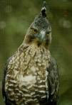
Java Eagles (Spizaetus bartelsi) is one medium-sized hawk species endemic (native species) in Java. These animals are considered identical with the symbols of the Republic of Indonesia, Garuda. And since 1992, the bird was designated as the mascot of the rare animals of Indonesia. I first saw the bird sightings directly Javanese eagle in mid-2005 in the vicinity of Water Three Pain at Mount Muria in Central Java. Unfortunately, until now I have not had the opportunity to watch for a second time.

Physically, the Eagles stand out as much as Java has crested 2-4 strands reaching 12 cm in length, because it is also called Eagle Eagle Kuncung Java. Adult body size (from tip of beak to tip of tail) approximately 60-70 inches, dark brown fur on the back and wings. Bercoretan dark brown stripes on the chest and abdomen dark brown thick. The tail is striped black and brown.
When flying, similar to Java Eagle Changeable Hawk (Spzaetus) form of light, but tend to appear more brownish, with a belly look darker, and slightly smaller size. Clarion high, repeatedly, or ii klii-iiw-iiiw, varies between one and three syllables. Or the sound of high pitched and fast-KLI-KLI KLI KLI-KLI-. In a sense, this voice sounds similar to the Changeable Hawk although the difference is quite clear in his tone.
Another picture, eyes and his eyesight is very sharp, sturdy beak, fluttering wings, powerful, high-powered cruisers, and when silence manly and authoritative figures. Impression of "male" is what probably inspired the 12 countries displaying the figure of a bird in a flag. Together with 19 other countries, Indonesia and even wearing her figure as a symbol of the country with the mythological bird garuda
Java eagle bird populations in the wild is estimated to live 600 rats. The World Conservation Agency of the United Nations mengategorikannya endangered. Convention on International Trade in Flora and Fauna in Endangered include them in Appendix 1, which means an extra set strict trade. Based on the latest from the IUCN criteria for endangered, Java Eagle included in the Endangered category or "Critical" (Collar et al., 1994, Shannaz et al., 1995). Through Presidential Decree No. 4 of 1993 on Wildlife and National Interest, The Government of Indonesia has confirmed Javanese Eagle as vice aerospace endangered species.
Java eagle flying eagle bird habitat on the island of Java Java is limited, especially in areas with primary forests and wooded hills in the area at the turn of the lowlands to the mountains.
Even today, this bird habitats narrowed due to the lack of forest ecosystems caused by human destruction, global warming, and the impact of pesticides. In West Java, only Java is available at Eagle Mountain Deconvolution, Mount Salak, Mount Gede Pangrango, Global Positioning System, Agriculture and Mountain Mist.
In Central Java are Javanese Eagle at Mount Slamet, Mount Ungaran, Mount Muria, Mount Lawu, and Mount Merapi, while in East Java is available at Merubetiri, Baluran, Alas Purwo, National Park, Bromo-Tengger-Semeru, and Willis

Gunung Gede National Park Pangrango (TNGGP)


TNGGP important as nature reserves of Indonesia. TNGGP can be taken 2 hours (100km) from Jakarta. TNGGP Area 21 975 ha. Th 1980 inaugurated a national park ..

In this forest, there Rasamala plant, Nepenthes, wild orchids, glowing mushrooms etc. Wildlife such as beetles, giant anteater, hundreds of species of mammals and 250 bird species also exist here. If lucky, can be found here langur, leopard, eagle, etc. Java. Ecology of forest can be enjoyed by climbing this mountain.
Cibodas entrance and Cibodas Botanical Garden will welcome, of course, in places accompanied with snacks souvenirs, plants and vegetables.
Enjoy a visit TNGGP, to forget the fatigue. Here not only enjoy but also learn this beautiful ecosystem.
Let's preserve the natural heritage and inheritance of future generations.
Ways to location:
Using the car
Select the path towards the Bogor toll road, exit direction Gadog Peak-Bandung. after 7, 6 km from the peak at T-junction turn right after the Outlet DSE. Continue 3km journey and arrived at the gate Cibodas akhirnta.
Entrance fee of Rp. 3000
Motor vehicles: Rp. 1000
After entering the gate, the road is straight and TNGGP office located on the right. Parking motorcycle / car in front of the office can. Free.
Using Public Transportation
Bandung by bus to the summit, and descends in Cibodas. From Cibodas ride public transportation to the National Park.
In addition there is the cost of admission tickets to the waterfall USD. 2000 (domestic) & USD. 20 000 (international) plus Rp. 500 (insurance).

Natural Exotic Papua

Paradise on Earth ARRIVES, Friday (9 / 4) and then to fill a show As You Like It is held by PT HM. Sampoerna tbk at the Hotel Aston Jayapura, Saturday (10 / 4) yesterday evening is an unforgettable children Naif Band.

With beautiful scenery, nice and exotic, the impression for David, Emil and Jarwo when first set foot in Papua.
"From the first principle if nyampe Papua wah've already feels complete, live doang Sabang in Aceh. I think it is beautiful Papua doang, Can not imagine something often happens here, "says vocalist Naif, David told the press after the event.
When a concert at the Hotel Aston mininya Jayapura, David assess the enthusiastic people of Jayapura on Naif very large. In fact, before David, Emil and Jarwo could not imagine for a gig in Papua will be like what his audience. "Attendance in Jayapura more than hope and our minds, it turns out they also gokil-gokil and fun," said Emil basisst Naif.
Naive drummer who appeared yesterday without Pepeng who should go home first to Jakarta due to her mother's illness, appear capable of engaging and entertaining community that are present in Jayapura As You Like It is.
Emil added, age-old during the tour to the affected areas in Indonesia, scene of the most insane and interesting of all the places visited by the most fun ever in Papua. "Carpet so the carpet like a mountain, valleys as well," said Emil.
Ending the interview, there are intentions to create Naif Papua typical song. "It could have come home from Papua can make, and if not inspiration fitting way," said David. [Anyong]

Bledug Kuwu, one of Indonesia's natural charm

The Indonesian natural resources are rich for its diversity in nature and culture. There are a lot of tourist spot; one of them is Bledug kuwu which is located in Purwodadi, central java.

This place is very unique; it is different from any other tourist object, it is named Bledug Kuwu. In United Stated there’s Salt Lake which came from the silting up of the sea and changed into land. In present time this land use as a testing place for the fastest vehicle in the world. It is different from the one that we have in Indonesia. It is also a nature wonder which no other countries have, it is called Bledug Kuwu. It is located in Kluwu village, kradenan district, Grobogan province. It is named Bledug Kuwu because of its sound that periodically make an explosion sound like Bledug (like an explosion of an artillery from the distance), from the mud bubble together with the coming out of the smoke, gases, and salty water. Through that process it became a land which it was from the bottom of the sea and now it became a mainland that reaches 53 meters height from the sea surfaces. The wide is 45 ha with the minimum temperature of 31° Celsius.


To be able to reach this place, we have to travel through the ground way from Semarang through Purwodadi until reaching the Kluwu village. During the journey we can see beautiful and fertile scenery of the nature, the spread of green rice fields and the blue sky. The beautiful view of the hills so fascinating so that the journey to this place won’t be quite boring, despite our eyes will be widely open and amaze by the scenery of the nature that green and amazing.

When we reach this place there’s a distinction view which is opposite with the view that we saw on the way to get this place. During the journey we can see the beautiful view but when we reach to this place it is so fallow and unfertile. But this kind of condition make this place so special because there is two kinds of conditions that opposite from one to another. Meanwhile we enjoy ourselves with the beauty of the nature; we also can see the local people who earn money as a salt farmer. From the source of salty water of Bledug Kuwu the farmer make it into kitchen salt. The quality of the salt from this area is very popular and it is written down in the history of Surakarta Royal Palace. It can be prove by the statement from the local people. In this area there are small mountains which on top of them let out a yellow mud.


Bledug Kuwu has its own specialty, if you see from the geological site, Dr. AJ Panekoek, stated that all lands that consist of Bledug is belong to alluvial plains (sediment soil or silting up soil) together with the explosion of Bledug, smokes, gases and salty water will come out from it. The sound of explosion happened because the coming out of the volcano which form into mud with grey color or dark grey but if this liquid mix with water it will become white. If you silt up this water eventually it will become lime land. It used to be sea that changed into land because of the erosion of the lime mountain, so the land consists of lime.

Indonesian natural

Natural resources in Indonesia is all natural potential that can be developed for production processes. Natural resources is all the natural wealth in the form of inanimate objects or living things that are in earth, and can be used to meet human needs.
The process of formation of natural resources in Indonesia is caused by various factors, among others:
1. Astronomically, Indonesia is located in the tropics with high rainfall causes a variety of plant species can flourish. Therefore, Indonesia is rich in various plants.
2. Geologically, Indonesia is located at the confluence of tectonic plate movement path and cause the formation of young mountain range of potential mineral resources to be exploited.
3. Oceans in the Indonesian region contains a variety of vegetable resources, animal, and minerals such as fish, seaweed, pearl and mines petroleum.
Distribution of Natural Resources
Biological resources consist of animal and vegetable spread on land and sea in addition to vast forests, Indonesia has the plantations and farms are spread almost all over Indonesia.
The number and quality of natural resources are many and scattered in various areas in Indonesia other than that quality is very good that can be exported in various countries so that they can meet the country's foreign exchange.
Types of natural resources exported as petroleum, natural gas and other mineral and agricultural products, horticulture, animal husbandry, fisheries, and tourism industries in addition to the results can also be exported out of the country.
Utilization of Natural Resources
Natural resources is one of the capital for development. As an authorized capital, natural resources should be utilized to its fullest, but in a way that is not damaging. Therefore, ways must be selected that can be used to maintain and develop so that authorized capital is more beneficial for future development.
Experts utilize natural resources with advanced technology. Qualified experts who will produce good quality seeds and produce a quality crop and produce a quality industry.
The technology used and developed tools that can rapidly accelerate and facilitate productivity tools used by Indonesian experts still less sophisticated as in developed countries but Indonesian experts can still produce a satisfactory natural resources.